|
App for ‘little known’ national treasure:
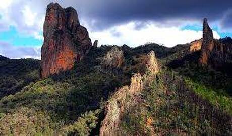
WANDERING THE WARRUMBUNGLES By Dallas Sherringham I have always wondered why the Warrumbungle Ranges are not more famous. They vault up out of the endless plains in north western NSW, providing an amazing sight from a distance and are even more amazing close up. And when you are sitting in amongst them with dozens of kangaroos grazing away without a care in the world, it takes your breath away. The trails within this park are outstanding. Shady walks along lazy creeks bubbling along followed by sudden vistas of dramatic landforms like the Breadknife and Belougery Split Rock. I guess the lack of coverage is the fact that we have a nation with outstanding rock features like Uluru with modern five star resorts, live shows, unique dining and an airport. The Warrumbungles have none of that…and that’s what makes it so special. Pitch your tent or pull up your caravan and you become part of a landscape of whispering trees and brilliant nights. In fact, the nights are so clear that the Warrumbungles is the home of an international observatory which is used by ‘star experts’ from around the world. But it is the stunning landform that is the real star attraction. Now visitors can now journey into an ancient volcano in Warrumbungle National Park with the help of a digital geotrail that provides a first-hand look at the molten lava, fire fountains and mud flows which once covered a large part of north west NSW up to 18 million years ago. Deputy Premier and Minister for Regional NSW John Barilaro said the Warrumbungle geotrail included fascinating findings from a new scientific paper prepared by the Geological Survey of NSW and revealed for the first time, a detailed history of the region’s violent volcanic past. Mr Barilaro said the trail could be easily downloaded through a user-friendly mobile app and was one of five in a network of digital geotrails allowing visitors to experience some of the most spectacular landscapes regional NSW had to offer. “Our geological scientists have uncovered the shape, size and lava flows of what we can determine was a shield volcano that existed after the dinosaurs became extinct and before humans walked the earth and now people can experience it first-hand,” Mr Barilaro said. “Thousands of visitors come to Warrumbungle each year to enjoy the site’s natural beauty and star gazing opportunities and through this new geotrail, we can now explore the remains of the huge volcano that gave rise to the local landscape. “There are trail options suited to a range of abilities including a self-drive tour, a leisurely stroll around what used to be the volcano’s main crater and an adventurous hike around the Grand High Tops Circuit with breathtaking views created by the volcano’s unique geology.” Mr Barilaro said the NSW Government’s growing geotrail network would lift the lid on hundreds of millions of years of geological history behind the Warrumbungle Volcano, Newcastle and Port Macquarie coastlines, Mutawinji National Park and the Central Darling region in the west. “We use handheld audio and visual guides in the world’s most famous museums and art galleries, and geotrails provide a similar experience accompanied by fresh air and unearthing facts about the rocks beneath our feet,” Mr Barilaro said. “Each trail is unique, covering local geological highlights and historic and cultural facts that will intrigue families, encourage them to stay longer and spend with local businesses.” Visitors can install the GeoTours NSW app on iOS or Android phones and tablets to download the Warrumbungle Volcano, Newcastle and Port Macquarie geotrails. About the NSW Geotrail network: • Port Macquarie Coastline Geotrail, (launched in 2018) – shows rocks made by volcanoes, by microscopic marine creatures and by underwater gravity currents. • Warrumbungle Volcano Geotrail – journey into an ancient volcano in Warrumbungle National Park where there is evidence of magma and what used to be the volcano’s main crater. • Newcastle Coastline Geotrail – showcases how the Newcastle coastline has changed across 250 million years and includes facts about volcanoes, a fossilised ancient forest, as well as Australia’s split from New Zealand • Coming soon (within 12 months): o Central Darling Geotrail – includes Mungo, Kinchega and Paroo-Darling National Parks, taking visitors through geological history including ancient dry lakebeds and fish fossils and details about Aboriginal culture o Mutawintji National Park Geotrail – journey through a 400 million-year-old seabed, learn about fossils and explore evidence of thousands of years of continuous Aboriginal occupancy and use of this rugged desert landscape. |
|
-
Home
-
NSW home
>
- NSW Central Coast >
- Victoria >
-
South Australia
>
-
Queensland
>
- Brisbane to Townsville
- Pacific Hotel Cairns
- Cairns to Karumba
- Hervey Bay
- Undara Lava Tubes
- Green Island Qld
- Brisbane to Townsville
- Lord Howe Island
- Yeppoon QLD
- O'Reilly's in the Wild
- The Whitsundays
- Barcaldine
- Brisbane Calile
- Sunshine State
- Brisbane Grand Ladies
- Heart Reef Qld.
- Uber Cool Brisbane
- Gambaro Hotel
- Adina Brisbane
- Port Douglas
-
CRUISING
>
-
Majestic Princess
>
- PRINCESS CAIRNS
- Volendam
- Holland America Orient >
- Paul Gauguin Cruises Tahitian Dreaming
- Blue Lagoon Cruises
- Sunborn Yacht Hotel
- Captain Cook Cruises Fiji
- CroisiEurope >
- Ponant Adventures in Style
- SeaDream Visits Elba
- Azamara Onward >
- SeaDream Memories
- CroisiEurope
- CroisiEurope Loire Valley
- CroisiEurope Rhine River >
- Silversea's Wild NZ
- The Rhine
- Riverboats
- Rhine Part 3
- Riverboat Cuisine
- Mekong Riverboat
- Lake Geneva
- Diamond Princess
- Multigenerational Cruising
- Cunard Queens
- Norwegian Cruise Lines >
-
SeaDream A Seven-Day Dream
>
- PNG with P&O
-
Celebrity Galapagos Cruise
>
- Celebrity Beyond
- Celestial Eclipse. Baltic
- Voyager of the Seas
-
MSC Seaside
>
- MSC Grandiosa >
- Holland America Koningsdam
- Sponsors
-
Destinations - Overseas
>
- Patagonia
- Ireland
- Guernsey
- Salzburg
- Austria's Silent Night
- Ethiopia
- Yorkshire
- Bryce Canyon
- Macao
- Dubai Taj
- Return to Sri Lanka
- The Copper Coast
- Nepal
- The Balkans Tour
- Disney Star Wars
- Indian Motorbike
- The Falkland Islands
- Rajasthan
- Marrakech
- Europe
- Ganges Odyssey
- Hokkaido
- Würzburg
- Tripura India
- Hong Kong Park Lane
- A Day in Hong Kong
- Zagreb Croatia
- Paris Hotels
- Majorca Hotel
- Dubai Hotel
- Croatia
- Flanders
- New Zealand
- Switzerland
- Wales
- Rabat, Morocco
- The Sahara
- Ireland's Movies
- Morocco Adventure
- Milwaukee
- Hong Kong Peak Tram
- Peru's Colca Valley
- Destination Africa
- Samoa Paradise
- Italy's Amalfi Coast >
- Sri Lanka Eco Lodge
- Cuba Cars
- Caribbean Airport >
- Kuala Lumpur
- Antarctica
- Cuba Revolution
- The Netherlands
- British Columbia Bears
- North to Alaska
- Winnipeg Canada
- Finland 'Escape'
- Thailand
- Germany
- Finland
- Malaysia Medical
- Stockholm
- The Havannah Vanuatu
- Deadwood, USA
- Helsinki cool
- French Village
- Vietnam
- UK Film Locations
- Cumbria England
- Doha Qatar
-
Archives
>
- The New Paklite Collection
-
Travel Books
>
- Latest Lonely Planet Kids
- Lonely Planet Kids’ Atlas of Monsters and Ghosts
- Lonely Planet Kids Stickers
- Lonely Planet Kids cardboard
- Lonely Planet Atlas >
- Lonely Planet Dark Skies
- Lonely Planet Dinosaurs
- Hardie Grant Books
- New Holland Publishers
- Endeavour
- Lonely Planet Wellness
- Child of Africa
- Where the Murray River Runs
- Lonely Planet’s Cruise Ports >
- Stealth Raiders Book
- Lonely Planent Cuisines
- Lonely Planet Earth
- Lonely Planet animal
- GOLF RESORTS BOOK
- Lonely Planet Kids
- Roped In from Hardie Grant
- Hawaiian Airlines
- The Steamboats of Lake Geneva
- Editorial Plan
- Contact
- Advertise
- Hong Kong with Helen
- Costa Rica Lindblad
- Ottawa
- Tokyo Disney Park >
- Tokyo DisneySea Dining
- Grey Nomad Awards
- Royal Caribbean >
- MSC CRUISES
- CROISIEUROPE
- Lonely Planet Books
- CAMERAS
- TRAVEL FINANCE
- DISABILITY TRAVEL
- Hawaii with Dal >
- Kimberley Quest
- Magazine
- Las Vegas
-
Majestic Princess
>
- AFRICA
- SAMOA
- Below Deck >
- JAPAN
- Year of the G.O.AT.
- Travbooks
- Media Kit >
-
NSW home
>
- Hawaii Dec 22
- Top 10 Jan 23
- Caravans 2023
- Emirates Feb 23
- Japan Jan 23
- Luke P&O Feb 23
- Santrini feb 23
- Driving the West feb 23
- Media Packs
- 20 things port stephens
- 20 things Airlie
- 20 things Taree
- 20 things Mission Beach
- 20 things Emerald
- 20 things Kangaroo Valley
- 20 things Cooma
- 20 things Toowoomba
- 20 things cruise ship
- 20 over 50 hollidays
- 20 eays for over 75
- 20 for Disabled
- 20 to take teeagers
- Grey Nomads
- Cruise Director P&O
- Greatest Trains
- 3001 is back!!
- HAL April
- Safe countries for women
- Untitled
- New Page
- McLachlan may 23
- Rim July 23
- Dangerous holidays
- Silversea Journeys
- Mykonos dining
